How to Research an Area Before Buying a House: The Complete 2026 Checklist
A practical, step-by-step checklist for researching any area before you buy, covering commute times, schools, crime, amenities, and transport links.
RightRoute Team
· Data & Research
· 21 April 2026

Most people spend longer researching a new laptop than they spend on the neighbourhood they're about to commit to for a decade. That's not a character flaw, it's just that property research is confusing, time-consuming, and spread across fifteen different websites. This checklist pulls it into one place.
Run through this before you view, not after you've fallen in love with the kitchen.
1. The commute, door to door
This is the one people get wrong most often. They check the station-to-station time, not the door-to-door time. Add 10 to 15 minutes each end for walking or driving to the station, and use the peak-hour service, not the off-peak one your estate agent might quote.
Things to check beyond the headline journey time:
- Service frequency. A 28-minute train that runs twice an hour is worse in practice than a 35-minute train that runs every 10 minutes.
- Annual season ticket cost. This is often the second-largest household expense after the mortgage. It's easy to underestimate when you're focused on the purchase price.
- Reliability. The Office of Rail and Road publishes operator cancellation and delay stats. Some routes are much worse than others.
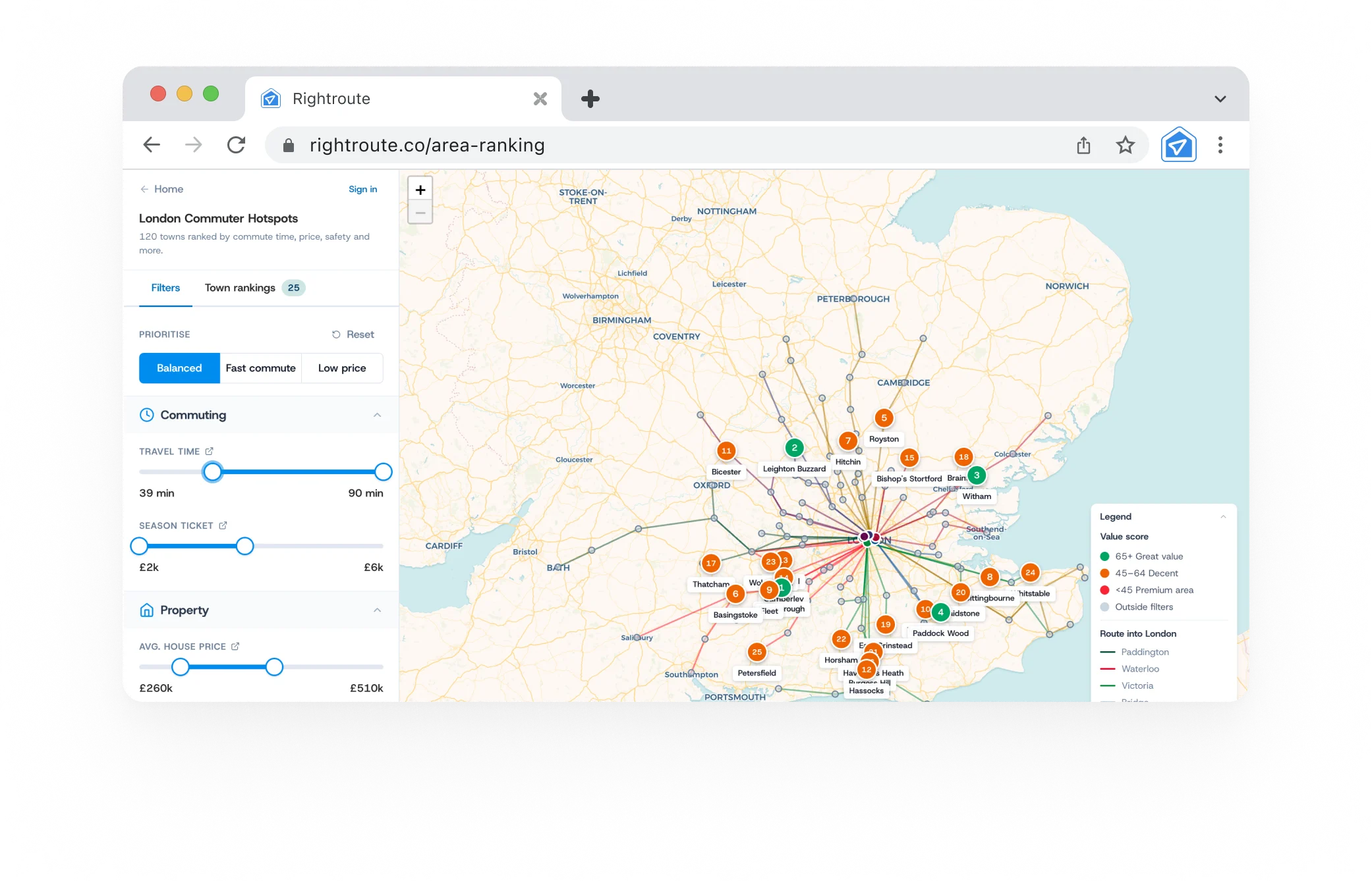
RightRoute's area comparison tool lets you build a scored shortlist where commute is one of several weighted criteria, so you can see how each area trades off against the others.
2. Schools, even if you don't have kids
School catchment areas directly affect house prices. A home in an Outstanding-rated primary's catchment can command a £30,000 to £50,000 premium over an identical property 300 metres outside it. That protects resale value regardless of whether you have children.
- Check Ofsted ratings for every school within walking distance.
- Cross-reference with the school's last published admissions distance. Catchment boundaries shrink as demand rises.
- For secondaries, look at Progress 8 scores (how much value the school adds) rather than just GCSE pass rates.
3. Crime stats over 12 months
police.uk gives you street-level crime data for any postcode in England and Wales. Use 12 months of data, not a single month. Crime is seasonal and one bad month can be misleading. Categories worth checking specifically:
- Burglary and vehicle crime (direct impact on insurance and peace of mind).
- Anti-social behaviour (often a leading indicator of neighbourhood trajectory).
4. Transport beyond the train
The train gets most of the attention but day-to-day life depends on more than that:
- Bus routes. Check the local council's network map for connections to hospitals, shopping, and schools.
- Cycling infrastructure. Sustrans' National Cycle Network shows dedicated routes. A good cycle route to the station can completely change your commute calculation.
- Station parking. Season ticket parking at some stations runs close to £2,000 a year. Worth knowing before you budget.
- Motorway access if you travel regionally for work.
5. Local amenities
These are the things that affect weekly life most directly. Run the list for each area you're seriously considering:
- Supermarket within 1 mile (otherwise you'll spend a lot of time in the car).
- GP surgery with reasonable waiting times. Check NHS ratings.
- NHS dentist accepting new patients. Harder to find than you'd think in some areas.
- A pub, cafe, or restaurant you'd actually want to go to on a Tuesday evening.
- Green space within walking distance. Google Maps satellite view is your friend here.
6. Flood risk
This one gets skipped most often and can be the most expensive to ignore. The Environment Agency's Flood Map for Planning shows flood zones across England. Zone 2 is manageable with appropriate insurance. Zone 3 can make a property very difficult to insure or remortgage. Takes 30 seconds to check and can save a lot of hassle.
7. Future development plans
Planning applications are public. The local council's planning portal shows everything approved or pending near any address. Worth looking for:
- Large housing developments that could increase traffic and pressure on schools.
- Commercial or industrial development near residential areas.
- Road schemes. A new bypass might improve access; a widened road at the end of your street might not.
8. Visit at different times of day
No amount of online research replaces being there in person. Try to visit on a weekday morning at commute time (is the station manageable?), a Saturday afternoon (is the high street alive?), and ideally after dark (some areas feel very different once street lighting is the only light source).
9. Talk to people who already live there
Estate agents are incentivised to sell. Locals are not. Introduce yourself in a local cafe or pub and ask what's changed in the last five years, and what they wish they'd known before moving. The answers are usually more useful than three hours of online research.
10. Score areas against each other
By the time you've done this for three or four areas, you'll have a lot of information but no clear answer. A scoring framework helps. Weight each factor by how much it matters to you, score each area out of 10, and compare.
RightRoute's area comparison tool is built for exactly this. Score on commute, price, town centre, greenery, neighbourhood, and schools, share the link with a partner so you each score independently, then compare results. It's free.
Quick checklist
- Peak-hour commute time, door to door
- Annual season ticket cost
- Train frequency and reliability
- School Ofsted ratings and catchment distances
- 12-month crime stats from police.uk
- Bus routes, cycling paths, motorway access
- Supermarket, GP, dentist, green space
- Flood risk via Environment Agency map
- Local planning applications
- In-person visits at multiple times of day
- Conversation with at least one local resident
Check any area's commute score before you buy: rightroute.co/app